Home > Science > Space Exploration > Space Rockets
Launch Preparation

![]()
Wall Art and Photo Gifts from Space Images
Launch Preparation
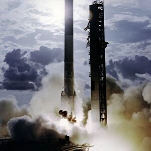
Inside the nose cone of this Delta rocket is Goddards geophysics research satellite, a 906-lb. (411-kg) satellite that looked more like a dimpled cosmic golf ball. The spacecraft, which NASA launched from the Western Test Range in California in 1976, provided a stable point in the sky to reflect pulses of laser light. By timing the return of the laser beam to an accuracy of about one ten-billionth of a second, scientists expected to measure the relative location of participating ground stations within one inch or a few centimeters. These measurements allowed scientists to track and analyze tectonic plate movement and continental drift. The spacecraft, called the LAser GEOdynamics Satellite (LAGEOS), was the precursor to the current-day Global Positioning System (GPS) system operated by the Defense Department
Space Image feature a selection of NASA's incredible imagery
Media ID 634543
© NASA
FEATURES IN THESE COLLECTIONS
> Science
> Scientists
> Science
> Space Exploration
> Space Rockets
> Space Images
> Departments
> Goddard Space Flight Center
EDITORS COMMENTS
This print showcases the intricate launch preparation of a Delta rocket, concealing within its nose cone Goddard's geophysics research satellite. The 906-lb. (411-kg) satellite resembled a fascinating dimpled cosmic golf ball, ready to embark on an extraordinary scientific mission. In 1976, NASA propelled this remarkable spacecraft from California's Western Test Range. The primary purpose of this innovative satellite was to serve as a stable reference point in the sky for reflecting pulses of laser light. With impeccable precision, scientists aimed to measure the return of the laser beam with an accuracy reaching one ten-billionth of a second. This groundbreaking technology enabled them to determine the relative location of participating ground stations within mere inches or centimeters. By tracking and analyzing tectonic plate movement and continental drift using these measurements, scientists unlocked invaluable insights into our ever-evolving planet. Named LAser GEOdynamics Satellite (LAGEOS), this pioneering spacecraft laid the foundation for today's widely utilized Global Positioning System (GPS) operated by the Defense Department. As we marvel at this photograph, we are reminded not only of humanity's relentless pursuit of knowledge but also our ability to harness cutting-edge technology for understanding Earth's dynamics on such minute scales. It serves as a testament to mankind's unwavering curiosity and determination in unraveling nature's mysteries from above and beyond.
MADE IN THE USA
Safe Shipping with 30 Day Money Back Guarantee
FREE PERSONALISATION*
We are proud to offer a range of customisation features including Personalised Captions, Color Filters and Picture Zoom Tools
SECURE PAYMENTS
We happily accept a wide range of payment options so you can pay for the things you need in the way that is most convenient for you
* Options may vary by product and licensing agreement. Zoomed Pictures can be adjusted in the Cart.